|
Scenic USA - California Crabtree Meadow |

| Photos by Rob Jones Wilderness Vagabond Trip Reports |
Offering some of the best  western hiking in America, the Pacific Coast Trail (PCT) covers a wide variety of climates, ranging from the lowland desert to some of the highest peaks of the Sierra-Nevada and Cascade mountain ranges. Winding its way through California, Oregon and Washington states, the PCT has become a challenging quest, with nearly 300 hikers per year covering the full 2650 mile length.
In contemplating PCT's rugged climbs, its isolated miles, glaciers and volcanoes, it's easy to compare the differences to its east coast counterpart, the Appalachian Trail.  Despite the fact that the Appalachian peaks attain only half the heights of the PCT and totals 500 miles less in length, Appalachian Trail (AT) hikers must spend more time achieving their goal. In fact it will take east coast hikers an additional month to cover the entire trail. On the west coast, when traversing the PCT’s long gradual grades, hikers tend to accomplish more miles per day. With its shorter season and snowfall coming early in the fall, this works well for Pacific Coast hikers who attempt
  to take on the entire trail.
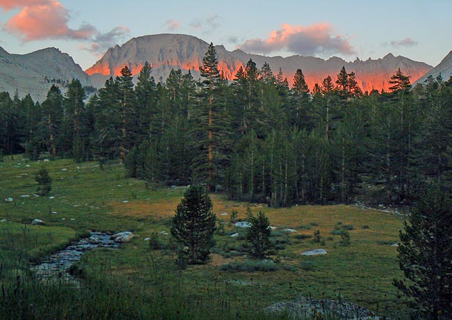
Here in east-central California, the PCT joins up with the John Muir Trail as backcountry hikers travel the mountaintops of some of the highest peaks of the Sierra Nevada Range. Seldom dipping below 10,000 feet, hikers experience the chill of high altitude trails. This late evening view captures a warm alpenglow when the last rays of sun cast a horizontal band across the mountaintops. Just after the sun disappears, a light frost begins to cover the meadow grasses. Off to the east, through the forest of lodgepole and foxtail pines, the glimmer of light reveals Pinnacle Ridge, Mount Young, Mount Muir and the granddaddy of the Lower 48, Mount Whitney.
Area Map

|
Additional Points of Interest |
|
Copyright © 2020 Benjamin Prepelka
All Rights Reserved
