|
Scenic USA - Oregon Columbia River Gorge |

| Photos by Ben Prepelka Ben Prepelka Photography |
![]() It takes about five hours of driving time to travel both sides of the Columbia River Gorge. Of course visiting here in the Gorge will take much more time. Dozens of waterfalls, charming towns and historic landmarks are just part of an in-depth visit to the Gorge. Although I-84 follows the southern edge of the Columbia River from Portland to Maryville, Washington’s Route 14 and Oregon’s Columbia River Highway offer a more leisurely drive on each side of the river.
It takes about five hours of driving time to travel both sides of the Columbia River Gorge. Of course visiting here in the Gorge will take much more time. Dozens of waterfalls, charming towns and historic landmarks are just part of an in-depth visit to the Gorge. Although I-84 follows the southern edge of the Columbia River from Portland to Maryville, Washington’s Route 14 and Oregon’s Columbia River Highway offer a more leisurely drive on each side of the river.
During November, 1805, the length of the gorge made up the final  leg of the Lewis and Clark Expedition, honored at the Lewis and Clark National Historic Site. The entire area is imprinted with many of their stopping points and landmarks. Beacon Rock, one of the world’s largest basalt monoliths, is one of the area's features named by Clark, a name that’s still in use today.
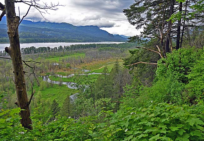
This overhead view of the Columbia River Gorge, seen from the Ponytail Falls Trail, looks out over a smooth flowing broad river. The river wasn’t always this peaceful. When Lewis and Clark arrived in 1805, the Bonneville Dam and Cascade Locks were not in existence. Dangerous rapids and Pacific tides presented Lewis and Clark with more challenges before their first view of the Pacific Ocean.
Area Map

|
Nearby Points of Interest |
Scenic USA Prints from
|
Copyright © 2022 Benjamin Prepelka
All Rights Reserved

