Kansas State Archives |
The Sunflower State
 Kansas, lying in the heart of Tornado Alley, sets the stage for the forever popular 1939 film, the Wizard of OZ. These broad plains are not only swept with devasating storms, but also filled with 19th century history. During a transition period from Indian Territory to homesteaders, the state's cattle drives, numerous railroad lines, and deep seeded political wars over the slavery filled its history pages. Dodge City reconnects visitors with its colorful past with Front Street shops and bars, the Boot Hill Cemetery, and stories of its rough and rowdy ways.
Today, the state is a leader in agriculture, producing wheat, soybeans, sorghum, and sunflowers. Eastern Kansas, part of the Grain Belt, is noted for cattle, hogs and corn.
Kansas visitors are drawn to its 10 national historic sites and preserves, plus 25 state parks and nine scenic byways located throughout the state.
| Feature Title: | Nearby City: |
|---|---|
| Louisburg Cider Mill | Louisburg |
| Neosho Falls | Neosho Falls |
| Feature Title: | Nearby City: |
|---|---|
| Hays Limestone Barn | Council Grove |
| Lower Fox Creek Schoolhouse | Strong City |
| Tallgrass Prairie Preserve | Strong City |
| Flint Hills Byway | Strong City |
| Pony Express Station | Marysville |
| Chase County Courthouse | Cottonwood Falls |
| Chase Lake Falls | Cottonwood Falls |
| Bushong Ghost Town | Bushong |
| Feature Title: | Nearby City: |
|---|---|
| Old Cowtown Museum | Wichita |
| Mushroom Rock | Cameiro |
| Old Oxford Mill | Oxford |
| Feature Title: | Nearby City: |
|---|---|
| Dodge City No. 1139 | Dodge City |
| Dodge City | Dodge City |
| Monument Rocks | Oakley |
| Smoky Valley Byway | Ogallah |
| Castle Rock | Quinter |
| Dalton Gang Hideout | Meade |
| Cimarron National Grassland | Wilburton |
 |
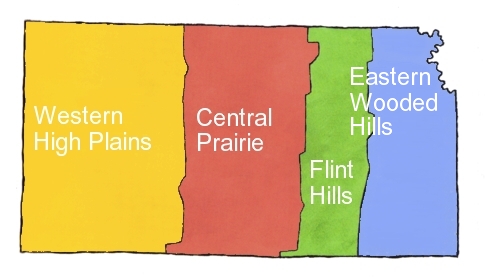
| Kansas Travel Regions Map |
Copyright © 2024 Benjamin Prepelka
All Rights Reserved

