|
Scenic USA - Wisconsin St Croix Riverside Landing |

| Photos by Ben Prepelka Ben Prepelka Photography |
The St. Croix River, a major tributary of the Mississippi River, creates a little more than a hundred miles of the Minnesota and Wisconsin border.  Originating in northwest Wisconsin, the St. Croix flows for 164 miles before joining the Mississippi just east of St. Paul. An outdoors paradise, the St. Croix and Namekagon rivers offer 255 miles of pristine water, green landscapes and only faint glimpses of human presence.
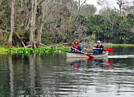
Protected under the National Wild and Scenic Rivers Act, the St. Croix National Scenic Riverway area surrounds the river, providing dozens of camping sites and river access points. The Riverside Landing Area, pictured here, is a great section of the river for canoeing and exploration.
Here in the Marshland area,  between Riverside Landing and Highway 70, the river gets substantially wider, with lower banks and some of the fastest moving water on the Riverway. This stretch of river introduces paddlers to the gentlest type of Class I river rapids, proving somewhat challenging to the inexperienced river goer. Besides its designation as a paddler's paradise, bird-watching and some of the best small mouth bass fishing are experienced in this scenic river area. While the Kettle River Slough is a great secret spot for fishing, low water and small ledges may prove to be troublesome during dryer periods. Contact one of the National Park Service visitor centers or check the web for the most up to date information and river levels.
Area Map
NPS Map

|
More Area Attractions |
|
Copyright © 2024 Benjamin Prepelka
All Rights Reserved
