|
Scenic USA - Alaska Juneau, a Bird's Eye View |

| Photos by Dan Kehlenbach Dan's Portraits of Alaska |
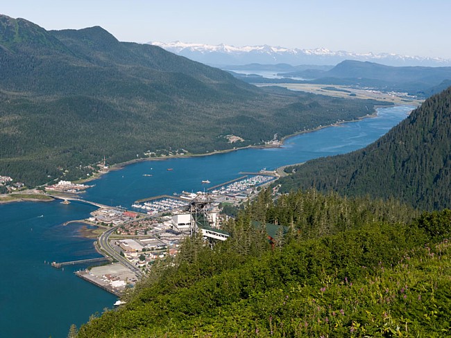
Named for prospector Joe Juneau, Alaskaís capital  city rests alongside the Gastineau Channel, fitting snugly against an imposing Mount Roberts and Mount Juneau. The Alaska Boundary Range isolates the city from
  the remainder of state, keeping its high speed ferries and international airport busy. Receiving upwards of 100 feet of snowfall every year, massive glacier fields rest atop the Boundary Ranges, including 3500 foot mountains above Juneau. The Mendenhall Glacier, Lemon Creek Glacier and Juneau Ice Field continue to amaze a million visitors every year.
Juneauís territory covers an area about the size of a small state, supporting a population of 30,000. The state capitol is located in downtown Juneau where governmental offices, a federal courthouse, post office and the Governor  reside. Moves to wrestle away its capital status have continued throughout the years, but Juneau has been able to defeat all the ideas of capital relocation.
This birdís eye scene offers one of the best views of the city's layout as Juneau is squeezed between the mountains and the banks of the Gastineau Strait. Its connection to the sea is obvious. Cruise ships and terminals line the water's edge along South Franklin Street. Coastal roads cover the narrow 45 mile corridor. Visitors may use rental cars or the public bus service to move around the city, while airline flights, helicopters, float planes, cruise ships and ferries are the only ways to travel in and out of the state capital.
Area Map

|
Nearby Points of Interest |
|
Copyright © 2020 Benjamin Prepelka
All Rights Reserved
