|
Scenic USA - Arkansas Route 7 Scenic Byway |

| Photos by Ben Prepelka Ben Prepelka Photography |
Arkansas Route 7 runs in a north-south direction, and on a map it appears to slice the state in two. The state route was Arkansas's first designated
scenic byway,  winding 290 miles from Lead Hill, near the Missouri state line, to El Dorado in the south at the Louisiana border.
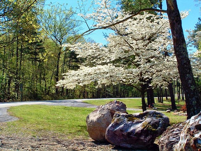
Route 7 makes the list of America's top ten scenic byways and passes through a range of natural wonders. Beginning in the northern section of the Natural State, stops at the Mystic Caverns, the 135 mile long free-flowing Buffalo National River, Rotary Ann Overlook, Pedestal Rocks and the woodlands of the Ozark National Forest create a sizable list to get things started. Heading southward, two state parks, Mount Nebo and Petit Jean State Park, take advantage of the beautiful Arkansas River Valley. A wonderful scenic drive most anytime of year, the scene pictured here on Route 7 at Blue Springs captures a springtime dogwood in full bloom. Just to the south is the Hot Springs National Park, the Ouachita National Forest, Ouachita River, and Poison Spring Battleground. Passing through the City of Hot Springs and Hot Springs National Park,  this famous area is where people have come for centuries to vacation and enjoy the benefits of its soothing thermal waters.
Coming to an end in the south, byway highlights include two very different state parks. History buffs will enjoy the story of the 1920s oil boom at the Arkansas Museum of Natural Resources, while the South Arkansas Arboretum State Park features 12 acres of natural beauty.
The entire scenic highway ushers byway travelers through four distinct Arkansas topographical regions, including the Ozark Plateau, Arkansas River Valley, Ouachita Mountains and the Coastal Plain. Sightseers should enjoy their experiences throughout the byway, including its large cities, small towns, numerous historic sites, countless natural wonders, national and state parks, and miles of rolling hills and dramatic mountain views.
Area Map

Copyright © 2020 Benjamin Prepelka
All Rights Reserved

